


County Clare
Contae an Chláir | |
|---|---|
 Lambang kebesaran | |
| Julukan: The Banner County (County Bendera) | |
| Motto: | |
 | |
| Negara | Irlandia |
| Provinsi | Munster |
| Established | 1565[3] |
| Kota county | Ennis |
| Pemerintahan | |
| • Otoritas lokal | Dewan County Clare |
| • Dáil constituency | Clare |
| • EP constituency | South |
| Luas | |
| • Total | 3.450 km2 (1,330 sq mi) |
| Peringkat | ke-7 |
| Ketinggian tertinggi (Moylussa) | 532 m (1,745 ft) |
| Populasi (2016)[4] | 118.817 |
| • Peringkat | ke-19 |
| Zona waktu | UTC±0 (WET) |
| • Musim panas (DST) | UTC+1 |
| Kunci ruteEircode | H62, H91, V14, V15, V94, V95 |
| Kode area telepon | 061, 065 (primarily) |
| Vehicle index mark code | CE |
| Situs web | www |
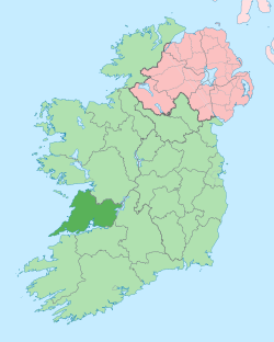
County Clare (bahasa Irlandia: Contae an Chláir) adalah sebuah county di Irlandia, di provinsi Munster, di sebelah barat berbatasan dengan Samudra Atlantik. Dewan County Clare adalah otoritas lokal. County ini memiliki populasi 118.817 pada sensus 2016. Kota county dan pemukiman terbesar adalah Ennis.[5]
County Clare berada di barat laut Sungai Shannon dengan luas total 3.450 kilometer persegi. Clare adalah county ketujuh terbesar dari 32 county Irlandia di luas wilayah dan terbesar ke-19 dalam hal populasi. County Clare berbatasan dengan dua county di Munster dan satu county di Connacht: County Limerick di selatan, County Tipperary di timur dan County Galway di utara. Julukan county Clare adalah Banner County (County Bendera).[6]
Referensi
sunting- ^ Lonergan, Aidan. "All 32 Irish county coat of arms, what they mean and where they come from". The Irish Post. Diarsipkan dari versi aslinya tanggal 12 April 2021. Diakses tanggal 8 October 2020.
- ^ "Clare History: What is Clare County Council's Coat of Arms?". www.clarelibrary.ie. Clare County Library. Diarsipkan dari versi aslinya tanggal 9 October 2020. Diakses tanggal 8 October 2020.
- ^ "County Clare - An Introduction". www.clarelibrary.ie. Diarsipkan dari versi aslinya tanggal 21 June 2019. Diakses tanggal 21 June 2019.
- ^ "Census 2016 Sapmap Area: County Clare". Central Statistics Office (Ireland). Diarsipkan dari versi aslinya tanggal 27 October 2018. Diakses tanggal 26 October 2018.
- ^ "Clare County Council Corporate Plan 2019-2024" (PDF). Clare County Council. Diarsipkan (PDF) dari versi aslinya tanggal 5 September 2020. Diakses tanggal 4 July 2021.
- ^ "Clare, The Banner County - World Cultures European". Irishcultureandcustoms.com. Diarsipkan dari versi aslinya tanggal 20 November 2020. Diakses tanggal 19 April 2012.
Pranala luar
sunting| Cari tahu mengenai County Clare pada proyek-proyek Wikimedia lainnya: | |
| Definisi dan terjemahan dari Wiktionary | |
| Gambar dan media dari Commons | |
| Berita dari Wikinews | |
| Kutipan dari Wikiquote | |
| Teks sumber dari Wikisource | |
| Buku dari Wikibuku | |
| Panduan wisata di County Clare dari Wikivoyage | |
