


The Côtes-d'Armor (/koʊt dɑːrmər/ koht dar-mər, /-dɑːrmɔːr/ -dar-mor; French pronunciation: [kot daʁmɔʁ] ⓘ; Breton: Aodoù-an-Arvor, [ˈoːdu ãn ˈarvor]), formerly known as Côtes-du-Nord until 1990 (Breton: Aodoù-an-Hanternoz, [ˈoːdu ãn ˌhãntɛrˈnoːs]), is a department in the north of Brittany, in northwestern France. In 2023, it had a population of 611,859.[3]
Côtes-d'Armor
Aodoù-an-Arvor (Breton) | |
|---|---|
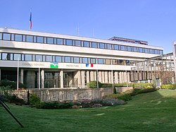 The departmental council and prefectural building in Saint-Brieuc. | |
 Flag  Coat of arms | |
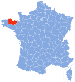 Location of Côtes-d'Armor in France | |
| Coordinates: 48°20′N 02°50′W / 48.333°N 2.833°W | |
| Country | France |
| Region | Brittany |
| Prefecture | Saint-Brieuc |
| Subprefectures | Dinan Guingamp Lannion |
| Government | |
| • President of the departmental council | Christian Coail[1] (PS) |
| Area | |
• Total | 6,878 km2 (2,656 sq mi) |
| Population (2023)[2] | |
• Total | 611,859 |
| • Rank | 42nd |
| • Density | 88.96/km2 (230.4/sq mi) |
| Time zone | UTC+1 (CET) |
| • Summer (DST) | UTC+2 (CEST) |
| Department number | 22 |
| Arrondissements | 4 |
| Cantons | 27 |
| Communes | 344 |
| ^1 French Land Register data, which exclude estuaries, and lakes, ponds, and glaciers larger than 1 km2 | |
History
editFrench Revolution
editCôtes-du-Nord was one of the original 83 departments created on 4 March 1790 following the French Revolution. It was made up from the near entirety of the ancient Pays de Saint-Brieuc, most of historical Trégor, the eastern half of Cornouaille, and the north-western part of the former diocese of Saint-Malo. The area had been part of the Province of Brittany before 1790.
World War II
editDuring the Second World War, Côtes-d'Armor was occupied by the Nazis and was the site of French Resistance operations, such as Operation Samwest, around the time of the Normandy landings.[4]
Post-War
editOn 27 February 1990, the name was changed to Côtes-d'Armor; the name is a portmanteau of the French word côtes means "coasts" and ar mor is "the sea" in Breton. The name also recalls that of the Roman province of Armorica ("the coastal region").
Geography
editCôtes-d'Armor is part of the current administrative region of Brittany and is bounded by the departments of Ille-et-Vilaine to the east, Morbihan to the south, and Finistère to the west, and by the English Channel to the north.
The region is an undulating plateau including three well-marked ranges of hills in the south. A granitoid chain, the Monts du Méné, starting in the south-east of the department runs in a north-westerly direction, forming the watershed between the rivers running respectively to the English Channel and the Atlantic Ocean. Towards its western extremity this chain bifurcates to form the Montagnes Noires in the south-west and the Monts d'Arrée in the west of the department. Off the coast, which is steep, rocky and much indented, are the Jentilez, Bréhat and other small islands. The principal bays are those of Saint-Malo and Saint-Brieuc.[5]
Principal towns
editThe most populous commune is Saint-Brieuc, the prefecture. As of 2023, there are 6 communes with more than 10,000 inhabitants:[6]
| Commune | Population (2023) |
|---|---|
| Saint-Brieuc | 44,364 |
| Lannion | 20,315 |
| Lamballe-Armor | 17,241 |
| Dinan | 14,764 |
| Plérin | 14,425 |
| Ploufragan | 11,507 |
Demographics
editThe inhabitants of the department are known in French as Costarmoricains.
Historical population | |||||||||||||||||||||||||||||||||||||||||||||||||||||||||||||||||||||||||||||||
|
| ||||||||||||||||||||||||||||||||||||||||||||||||||||||||||||||||||||||||||||||
 | |||||||||||||||||||||||||||||||||||||||||||||||||||||||||||||||||||||||||||||||
| Sources:[7][3] | |||||||||||||||||||||||||||||||||||||||||||||||||||||||||||||||||||||||||||||||
Politics
editCôtes-d'Armor's long tradition of anti-clericalism, especially in the interior around Guingamp (a former Communist stronghold), has often led to the department's being seen as an area of left-wing exceptionalism in a region that historically was otherwise strongly Catholic and right-wing. The current president of the departmental council, Christian Coail, is a member of the Socialist Party.
| Party groupings | seats | |
|---|---|---|
| Centre et droite républicaine | 32 | |
| Socialiste et républicain | 15 | |
| Communiste et républicain | 5 | |
| non-party | 2 | |
Current National Assembly Representatives
editCulture
editThe western part of the department is part of the traditionally Breton-speaking "Lower Brittany" (Breizh-Izel in Breton). The boundary runs from Plouha to Mûr-de-Bretagne. The Breton language has become an intense issue in many parts of Brittany, and many Breton-speakers advocate for bilingual schools. Gallo is also spoken in the east and is offered as a language in the schools and on the baccalaureat exams.
Gallery
edit-
-

-

-

-
 Castel Meur house in Plougrescant
 -
 Statue of Bertrand du Guesclin in Dinan
 -
 Seen from a hiking trail
 -
 Gannets on Rouzic Island
 -
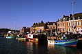
 Small harbour at high tide
 -
 The coast
Notable people
edit- Anne Beaumanoir (1923–2022), one of the Righteous Among the Nations, was born in Guildo.
- Bernadette Cattanéo (1899–1963), trade unionist and militant communist
- English-born poet Robert William Service (1874–1958), known as the "Bard of the Yukon", is buried in Lancieux.
See also
editReferences
edit- ^ "Répertoire national des élus: les conseillers départementaux". data.gouv.fr, Plateforme ouverte des données publiques françaises (in French). 4 May 2022.
- ^ "Populations de référence 2023" (in French). National Institute of Statistics and Economic Studies. 18 December 2025.
- ^ a b Population municipale entre 1968 et 2023, INSEE
- ^ "History of operation Samwest in June 1944 in Britanny". dday-overlord.com. 19 February 2016. Archived from the original on 28 May 2024. Retrieved 6 March 2025.
- ^ One or more of the preceding sentences incorporates text from a publication now in the public domain: Chisholm, Hugh, ed. (1911). "Côtes-du-Nord". Encyclopædia Britannica. Vol. 7 (11th ed.). Cambridge University Press. p. 249.
- ^ Populations de référence 2023: 22 Côtes-d'Armor, INSEE
- ^ "Historique des Côtes-d'Armor". Le SPLAF.
- ^ "Assemblée nationale ~ Les députés, le vote de la loi, le Parlement français". assemblee-nationale.fr.
External links
edit- (in French) Prefecture website
- (in French) Departmental Council website
- (in French) Tourist board website
