


This article may require copy editing for grammar, style, cohesion, tone, or spelling. (July 2025) |
Culiacán, officially Culiacán Rosales, is the capital and largest city of Sinaloa in northwestern Mexico. It is located within the Culiacán Municipality. The city was founded on 29 September 1531 by the Spanish conquistadors Lázaro de Cebreros and Nuño Beltrán de Guzmán originally under the name "Villa de San Miguel", in honor of its patron saint Michael the Archangel.
Culiacán | |
|---|---|
City | |
| Culiacán Rosales | |
     Left to right: Panoramic view of the city · Culiacán Botanical Garden · Culiacán Cathedral · Tres Ríos District · Monumental letters · Tomateros de Culiacán baseball monument · Sunset in Culiacán | |
 Coat of arms | |
| Nickname: La Perla del Humaya (The Pearl of the Humaya) | |
 Culiacán Location in Sinaloa  Culiacán Location in Mexico | |
| Coordinates: 24°48′25″N 107°23′38″W / 24.80694°N 107.39389°W | |
| Country | Mexico |
| State | Sinaloa |
| Municipality | Culiacán |
| Foundation | 1531 |
| Government | |
| • Municipal president | Juan de Dios Gámez Mendívil (Morena) |
| Area | |
• City | 65 km2 (25 sq mi) |
| Elevation | 71 m (233 ft) |
| Population (2020) | |
• City | 860,500 |
| • Density | 13,000/km2 (34,000/sq mi) |
| • Metro | 1,003,530 |
| Demonym(s) | culiacanense, "culichi" |
| GDP (PPP, constant 2015 values) | |
| • Year | 2023 |
| • Total (metro area) | $17.8 billion[1] |
| • Per capita | $20,000 |
| Time zone | UTC−7 (MST) |
| Waterways | Tamazula River, Humaya River, Culiacán River |
| Airports | Federal de Bachigualato International Airport |
| Public transit | RedPlus |
| Railroads | Ferromex Culiacán Station |
| Website | www |
According to the 2020 INEGI census, Culiacán had an estimated population of 808,416, making it the 21st most populous city in Mexico. Its metropolitan area, with a population of 1,003,530, was the 17th most populous metropolitan area in Mexico.
The city sits in a valley on the slopes of the Sierra Madre Occidental, at the confluence of the Tamazula and Humaya Rivers, where both join to form the Culiacán River 55 meters above sea level.
Etymology
editThe name derives from the Nahuatl colhua ("ancestor" or a tribal name) and the locative –cán ("place"), rendering "place of the Colhua". Some historians alternatively interpret it as "snake place" or "crooked hill". The most accepted theory is "place of the colhuas", or "inhabited by the colhua tribe", and the most frequent meaning is "place of worshiping the god Coltzin".[2][3][4]
History
editPrehispanic era
editAn ancient indigenous settlement called Huey Colhuacan dates back to Tecpatl, corresponding to the year 628 CE. The Aztecs built it during their pilgrimage. Its exact location is unknown, but it is generally assumed that it was close to the current town of Culiacáncito.[citation needed]
Founding
editThe city known today as Culiacán was co-founded in 1531 by conquistadors Lázaro de Cebreros and Nuño Beltrán de Guzmán under the name "Villa de San Miguel". Upon their arrival in the 16th century, the Spanish found the existence of farmhouses organized in indigenous nations by the tribe of the Tahues, which brought together a group of people of the same origin and language who had a common tradition.
Other indigenous peoples that inhabited the original territory of Culiacán were the Tebacas, Pacaxes, Sabaibo, and Achires.
After their war of conquest in 1531, de Cebreros and de Guzmán organized the territories acquired into three provinces. One of them was Culiacán, which was delimited to the South by the Elota River and to the North by the Mocorito River, depending on the Kingdom of Nueva Galicia. Organized in this way, the territory lasted until 1786, the year in which the administration system was implemented,[clarification needed] with Sonora and Sinaloa forming the province of Arizpe and the older province of Culiacán remaining the same.
Independent Mexico
editOn 6 October 1821, independence was sworn in Culiacán. Culiacán was granted the category of city on 21 July 1823, when the provinces of Sonora and Sinaloa separated by decree from Congress. In 1824, by the Constitutive Act of the Mexican Federation, Sinaloa and Sonora reunited, forming the Estado de Occidente. On 13 October 1830, the provinces of Sonora and Sinaloa were definitively separated by decree, with the city of Culiacán designated the capital of the state of Sinaloa. In 1861, during the conservative government of the French Intervention, prefectures were installed, and the Municipalities Law was enacted that divided the Districts into City Councils. The Badiraguato District was suppressed and became part of the Culiacán District as a municipality.
From 1859 to 1873, the capital of Sinaloa was moved from Culiacán to Mazatlán. In the Restored Republic, Governor Eustaquio Buelna confronted the merchants of the port. He returned to Culiacán, and the Local Congress gave it the status of capital of the state.
Porfirian and revolutionary times
editIn 1878, Culiacán had three City Halls, whose headwaters were Culiacán, Quilá, and Badiraguato. This remained the case until 1880 when Badiraguato returned to being a district with the limits that previously corresponded to it.
Municipalities were established by law in 1912 as a new form of internal government. However, this law did not come into force until 1915, when political directories were suppressed, causing the districts to become free municipalities. Culiacán was established as a municipality by decree on 8 April 1915. Within its original limits was the current Municipality of Navolato, which was segregated from Culiacán on 27 August 1982, depriving the city of 2,285 square kilometres (882 mi2) of valley agriculture.

Sometime later, the State Congress approved the extension of the capital city's name, giving it its current official name of Culiacán de Rosales. "Rosales" honors the great Mexican military man Antonio Rosales, who fought in the second French Intervention and the Reform War, along with serving as the governor of Sinaloa.
World War II and opium cultivation for morphine
editDuring World War II, the United States experienced shortages of medical morphine after opium supplies from Asia were disrupted by the Pacific War. In response, Mexican authorities, in cooperation with U.S. officials, expanded regulated opium poppy cultivation in northwestern Mexico, including rural areas surrounding Culiacán in the state of Sinaloa.[5] Farmers in the mountainous regions of Sierra Madre Occidental, near the city produced opium that was processed into legal morphine for wartime medical use by Allied forces. Although the program ended after 1945, the agricultural knowledge, smuggling routes, and local intermediary networks developed during the wartime period persisted. Historians and criminologists have identified these postwar networks as an early foundation for later illicit drug trafficking organizations in Sinaloa.[6]
After World War II
edit
From the late 1950s onward, Culiacán emerged as a major hub for drug trafficking to the United States. The completion of the Pan-American Highway and the regional airport in the 1960s accelerated the expansion of workable distribution infrastructure for the enterprising few families that would later come to dominate the international drug cartels along Mexico's Pacific Northwest. The Sinaloa Cartel made Culiacán its primary base.[7]
On 17 October 2019, after an ultimately unsuccessful attempt to arrest one of the Sinaloa Cartel's leaders, widespread gunfights broke out across the city, leading to multiple deaths, in what has been called the "Battle of Culiacán". One of Joaquín "El Chapo" Guzmán's relatives, Ovidio Guzmán, was arrested, but the police were eventually forced to release him.[8]
Coat of arms
edit
The coat of arms for both the municipality and the city of Culiacán has various elements that represent their history.
Rolando Arjona Amábilis designed the coat of arms, and on 26 May 1960 municipal decree number 13 made his design Culiacán's official coat of arms. It was published in number 90 of the Official Newspaper of the State of Sinaloa on 30 July 1960. Its shape is square with rounded corners ending in a point. The entire face of the shield is covered with a carmine color. A hieroglyph sits in the middle representing a hill with a human head bowing forward. The glyph alludes to Coltzin, "the crooked god," an authentic figure of Nahua mythology, who gave his name to the Nahuatlaca-Colhua tribe and to the town they lived in, Colhuacán or Teocolhuacán.
Across the front of the shield, there are blue lines representing rivers. A black cross sits in the middle left next to a path with footprints that lead to a small structure in the top right. These motifs symbolize the missionaries who ventured north from San Miguel de Culiacán, and pays homage to their benevolence and heroism.
The border bears the Spanish name "Culiacán" at the top and the Nauhatl name "Colhuacán" at the bottom. At the top of the shield is a hill with a germinating seed and a golden sun, alluding to the tropical climate of the region and to the agriculture industry.[9]
Politics
edit
The government of the municipality of Culiacán corresponds to its City Council, which is elected by a universal, direct, and secret vote for a period of three years. The term is not renewable for the immediate period but can be continuous. The elected officials begin to exercise their position on 1 January of the year following the election. The City Council is composed of the Municipal President, a Procurator Trustee, and a body of councilors consisting of 18 representatives elected by relative majority and seven by the principle of proportional representation.
Syndications
editFor its internal regime, the municipality is subdivided into 17 receiverships, which in turn are divided into police stations. The 17 receiverships of the municipality are: El Salado, Higueras de Abuya, Baila, Aguaruto, Emiliano Zapata, Adolfo López Mateos (El Tamarindo), Jesús María, Las Tapias, Quilá, Sanalona, San Lorenzo, Tacuichamona, Tepuche, Imala, Costa Rica, Culiacáncito, and Eldorado.
Paramunicipals
edit- Culiacán Zoo
- JAPAC
- Municipal Institute of Sports and Physical Culture (IMDEC)
- EME Park (87)
- Municipal Institute of Culiacán Women (IMMUJERES)
- MIA Institute (MIA Museum & MIA Auditorium)
- Culiacán Municipal Institute of Culture (IMCC)
- Housing Institute
- DIF Culiacán
- The Chronicle of Culiacán
- Municipal Institute of Youth (IMJU)
- Municipal Commission of Populated Centers of Culiacán (COMUN)
- IMPLAN
- COMPAVI
Geography
edit
Location
editCuliacán is located in the central region of the State of Sinaloa, forming part of the Northwest of Mexico. The coordinates that correspond to it are 24 ° 48'15 "N (latitude) by 107 ° 25'52" W (West), with an altitude of 54 meters above sea level.[citation needed]
The city is located 1,240 kilometres (770 mi) from Mexico City. From Culiacán to Tepic is only 502 km; to Durango, 536 km; to Hermosillo, 688 km; to Guadalajara, 708 km; to Monterrey, 1,118 km; to Chihuahua, 1,159 km; to Tijuana, 1,552 km; and to Matamoros, 1,434 km.[10]
Relief and hydrography
editThe relief of the municipality is well defined by a mountainous part and the coastal plain. The mountainous part corresponds to the physiographic region of the highlands, part of the Pacific slope of the Sierra Madre Occidental mountain range with elevations of 300 to 2,100 meters above sea level.[11] The coastal plain lies to the West and is crossed by four regional rivers: the Humaya, Tamazula, Culiacán and San Lorenzo. The Humaya has its origin in the State of Durango, entering Sinaloa through Badiraguato; its waters are controlled by the Licenciado Adolfo López Mateos dam. The Tamazula River arises in the Sierra Madre Occidental near the Topia Valley; its waters are controlled by the Sanalona dam. The Humaya and Tamazula Rivers unite in front of the city of Culiacán to form the Culiacán River, which empties into the Gulf of California. The San Lorenzo is borne from the Sierra Madre Occidental within the State of Durango, enters Sinaloa through Cosalá and empties into the Gulf of California.
Climate
edit Culiacán has a hot semi-arid climate (Köppen: BSh), despite receiving an annual rainfall over 600 mm (24 in), due to its hot temperatures and high evaporation. Summers are very hot and humid, shade temperatures can reach 45 °C (113 °F) and high humidity can produce heat indices of 50 to 55 °C (122 to 131 °F), with the risk of heavy rainfall from decaying tropical cyclones also present. Winters are much milder, with less humidity and an average high of 27 °C, with warm nights.
| Climate data for Culiacán (1991–2020) | |||||||||||||
|---|---|---|---|---|---|---|---|---|---|---|---|---|---|
| Month | Jan | Feb | Mar | Apr | May | Jun | Jul | Aug | Sep | Oct | Nov | Dec | Year |
| Record high °C (°F) | 41.0 (105.8) |
42.0 (107.6) |
39.0 (102.2) |
41.5 (106.7) |
43.0 (109.4) |
45.5 (113.9) |
43.5 (110.3) |
46.0 (114.8) |
42.5 (108.5) |
44.2 (111.6) |
42.5 (108.5) |
37.0 (98.6) |
46.0 (114.8) |
| Mean daily maximum °C (°F) | 28.5 (83.3) |
29.4 (84.9) |
31.4 (88.5) |
33.8 (92.8) |
36.1 (97.0) |
37.3 (99.1) |
36.8 (98.2) |
36.1 (97.0) |
35.4 (95.7) |
35.8 (96.4) |
32.5 (90.5) |
28.6 (83.5) |
33.5 (92.3) |
| Daily mean °C (°F) | 20.4 (68.7) |
21.0 (69.8) |
22.6 (72.7) |
24.9 (76.8) |
27.9 (82.2) |
30.9 (87.6) |
30.8 (87.4) |
30.2 (86.4) |
29.8 (85.6) |
28.9 (84.0) |
24.8 (76.6) |
20.8 (69.4) |
26.1 (79.0) |
| Mean daily minimum °C (°F) | 12.2 (54.0) |
12.6 (54.7) |
13.7 (56.7) |
16.0 (60.8) |
19.6 (67.3) |
24.4 (75.9) |
24.7 (76.5) |
24.3 (75.7) |
24.2 (75.6) |
22.1 (71.8) |
17.1 (62.8) |
13.1 (55.6) |
18.7 (65.7) |
| Record low °C (°F) | 2.0 (35.6) |
2.0 (35.6) |
3.0 (37.4) |
3.0 (37.4) |
9.0 (48.2) |
12.0 (53.6) |
13.0 (55.4) |
16.0 (60.8) |
17.0 (62.6) |
11.0 (51.8) |
5.0 (41.0) |
3.0 (37.4) |
2.0 (35.6) |
| Average precipitation mm (inches) | 13.8 (0.54) |
14.4 (0.57) |
2.7 (0.11) |
1.3 (0.05) |
1.1 (0.04) |
18.0 (0.71) |
151.3 (5.96) |
216.1 (8.51) |
187.5 (7.38) |
42.8 (1.69) |
22.3 (0.88) |
15.9 (0.63) |
687.2 (27.06) |
| Average precipitation days (≥ 0.1 mm) | 2.4 | 2.5 | 1 | 0.5 | 0.6 | 3.5 | 15.7 | 17.2 | 13.1 | 3.4 | 2.5 | 2.4 | 64.8 |
| Average relative humidity (%) | 72 | 70 | 67 | 65 | 64 | 67 | 72 | 75 | 75 | 72 | 71 | 72 | 70 |
| Mean monthly sunshine hours | 189.1 | 186.5 | 229.4 | 213.0 | 248.0 | 222.0 | 192.2 | 198.4 | 195.0 | 229.4 | 213.0 | 182.9 | 2,498.9 |
| Mean daily sunshine hours | 6.1 | 6.6 | 7.4 | 7.1 | 8.0 | 7.4 | 6.2 | 6.4 | 6.5 | 7.4 | 7.1 | 5.9 | 6.8 |
| Source 1: Servicio Meteorológico Nacional (humidity, 1981-2000)[12][13][14] | |||||||||||||
| Source 2: Deutscher Wetterdienst (sun, 1941–1970)[15] | |||||||||||||
Demographics
editPopulation dynamics
editThe Municipality of Culiacán has a total population of 858,638 inhabitants, this according to the 2010 Population and Housing Census carried out by the National Institute of Statistics and Geography (INEGI).[16] It has a population density of 166.8 inhabitants / km2,[17] the Municipality concentrates 31% of the population in the State of Sinaloa, with 422,507 men and 436,131 women, with a ratio of 96.9 men for every 100 women.[16]
The city of Culiacán Rosales occupies only a part of the municipality of Culiacán and in 2010 had an urban area of 65 km2, being the largest in the state of Sinaloa and has a population of 675,773 inhabitants (of which 329,608 are men and 346,165 are women), according to the 2010 Population and Housing Census carried out by the (INEGI), resulting in a population density of 10,396.5 inhabitants / km2.[18] concentrating 78.7% of the total urban population of the Municipality. The ethnic groups most represented in the Municipality are the Mixtec and Nahuatl,[19] the total population of indigenous language speakers (HLI population) is 13,081 people.[20] On the other hand, in the urban area of Culiacán, there are only 3,536 indigenous people.
The city ranks 20th in number of foreign population, which amounts to 6,693 inhabitants, which represent almost 1% of the total population; Among the main nationalities are Americans, Canadians, Spanish, Italians, Greeks, Argentines, Cubans, Colombians, Brazilians, Chinese, Japanese, Russians, Ukrainians, Venezuelans, Dominicans, Germans, among others.
The presence of people of Greek origin that occurred in the 1940s and 1950s coincided with the incipient but flourishing emergence of agriculture. This attracted a lot of Hellenic labor for the tillage of the land. This attracted a greater number of people; today, they make up the few thousand people who continue to live in the city. It is believed that the Greek community is the largest in Mexico.
| Year | 1900 | 1910 | 1920 | 1930 | 1940 | 1950 | 1960 | 1970 | 1980 | 1990 | 1995 | 2000 | 2005 | 2010 | 2015 |
|---|---|---|---|---|---|---|---|---|---|---|---|---|---|---|---|
| Population | 10,380 | 13,527 | 16,034 | 18,202 | 22,025 | 48,936 | 85,024 | 167,956 | 304,286 | 415,046 | 505,518 | 540,823 | 605,304 | 675,673 | 858,638 |
Housing and urbanism
editThe total number of dwellings that exist in the city is 221,144, of which only 176,799 dwellings are occupied, with an average of 3.81 inhabitants per inhabited dwelling.[citation needed] In general, cement roofs, walls, and floors are used for the construction of the house, although homes or buildings do not cease to exist, most of them have sheet roofs and earth floors. This occurs mainly in the area peripheral to the south of the city, where settlements of new inhabitants are growing in number.

Of the 176,799 occupied dwellings, 173,704 have electricity, 171,614 have piped water, 171,489 have drainage, and 169,550 have the 3 services simultaneously.[citation needed]
Among the noteworthy buildings are Torre Tres Ríos, Torre Santa María, Torre Tres Afluencias, Mileto 4 Ríos, Estela Corporate Center, Ceiba, BioInnova Building, Tower 120, and Dafi, all located in the Tres Ríos Urban Development district.
City zoning
editThe city is divided into different areas mainly:
The Historical Center of Culiacán is the original area of the city, in which most of the buildings of the Spanish colonization between the 16th and 19th centuries are found, it comprises a territorial extension of approximately 247,123 ha (2,471 km2). From the '70s onwards, there was a process of depopulation of the area due to the high costs of rents, the bustle of the main streets and avenues, and the priority of having more commercial spaces, but in recent years there has been a process of repopulation of the same with the construction of apartments in the periphery of the center and a project of urban reorganization in which it is intended to have a higher population density.

Las Colonias, which are the first settlements that populated the perimeter around the original urban area by people from different social strata to have a largely wide space close to the center; Among the best known and with the largest population, we find: Infonavit Humaya, Tierra Blanca, 6 January, Stase, Juntas de Humaya, Almada, Miguel Alemán, Centro Sinaloa, Morelos, Palmito, El Barrio, Aurora, etc.
The subdivisions are areas divided by various construction companies, where certain sections feature the same style of housing, accommodating people of lower middle class, middle and upper middle class. Among the most well-known are: La Conquista, Villas del Rio, Valle Alto, Los Pinos, Villa Verde and Villa Fontana. Residentials are considered to be areas strategically built for people with high purchasing power, with spacious houses, and large green areas. In most cases, they are private. Examples of these neighborhoods include: Tres Ríos, Chapultepec, Los Álamos, Guadalupe, Lomas de Guadalupe, Colinas de San Miguel, Montebello, La Campiña, Las Quintas, Isla Musalá and La Primavera.
Economy
editCuliacán's economy is mainly agricultural and commerce. It is a trade center for produce, meat, and fish. Among other industries, Culiacán represents 32 percent of the state economy.
Coppel, Casa Ley, Homex, and other companies of national importance are headquartered in Culiacán.
Administrative divisions
editCuliacán is divided into 27 sectors (sectores), which are groups of several quarters (colonias):
| Administrative divisions of Culiacán | ||
 |
Demarcaciones territoriales | Sector |
| Riberas | 01 | |
| Centro (primer cuadro) | 02 | |
| Las Quintas | 03 | |
| Isla Musalá | 04 | |
| Universitarios | 05 | |
| Tres Ríos | 06 | |
| Patio de Maniobras | 07 | |
| Juntas del Humaya | 08 | |
| Río Culiacán | 09 | |
| Guadalupe | 10 | |
| Colinas de San Miguel | 11 | |
| Abastos | 12 | |
| El Barrio | 13 | |
| Los Ángeles | 14 | |
| Mirador Tamazula | 15 | |
| Humaya | 16 | |
| La conquista | 17 | |
| Bacurimi | 18 | |
| Villas del Río | 19 | |
| Bachigualato | 20 | |
| Díaz Ordaz | 21 | |
| Barrancos | 22 | |
| San Isidro | 23 | |
| Loma de Rodriguera | 24 | |
| La Higuerita | 25 | |
| Aguaruto | 26 | |
| La Costerita | 27 | |
Education
edit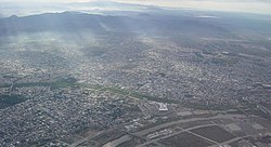

Universities
edit- Centro de Estudios Universitarios Superiores (CEUS)
- Escuela Libre de Derecho de Sinaloa
- Instituto Tecnológico de Culiacán
- Instituto Tecnológico y de Estudios Superiores de Monterrey (ITESM) – Campus Sinaloa
- Instituto Tecnológico Superior de Sinaloa – Campus Culiacán
- Universidad Asia-Pacifico
- Universidad Autónoma de Durango-Campus Culiacán
- Universidad Autónoma de Sinaloa
- Universidad Casa Blanca
- Universidad Católica de Culiacán
- Universidad Golfo de México – Campus Culiacán
- Universidad México Internacional
- Universidad de Occidente – Campus Culiacán
- Universidad de San Miguel (USM)
- Universidad TecMilenio – Campus Culiacán
- Universidad Tecnológica de Sinaloa
- Universidad Valle del Bravo – Campus Culiacán
- Universidad de Veracruz – Campus Culiacán
- Universidad Tecnológica de Culiacán
- Instituto Chapultepec
Transportation
editThe Terminal de Autobuses de Culiacán or Central de Autobuses Culiacán Millenium is a bus terminal located west of Culiacán, Sinaloa, Mexico.
Transit system
editUrban transport
editAs of 2024, Culiacán has just over 68 urban transport routes, which serve about one million users. The Culiacán urban transport is operated by RedPlus.[21]
Rail
editThe city has a train station operated by Ferromex, which is used only to transport freight. It is connected to Mazatlán in the south and Guaymas in the north.
Bus station
editCuliacán uses the "Millennium" International Bus Station ("Central Internacional de Autobuses "Millennium) to travel across of Mexico and to the United States (Arizona and California).
Roads and expressways
editThough several high-speed roads have been built, most of the city's streets are rather narrow, and traffic jams are common during rush hour. There are 300,000 cars in Culiacán, making the per capita number of cars one of the highest in the country.[citation needed]
Main roads
editCuliacán has several roads (avenues, boulevards, streets, etc.), but some of these are the main quick motor vehicle connection to other points of the city.
- Álvaro Obregón Ave
- Francisco I. Madero Blvd.
- Paseo Niños Heroes
- El Dorado Ave
- Aeropuerto
- Emiliano Zapata Blvd.
- Benjamín Hill Ave
- Calzada de las Torres
- México 68
- Plan Mar de Cortes
- Heroico Colegio Militar
- Revolución Ave
- Sanalona Way
- Rolando Arjona Amabilis Blvd.
- Universitarios
- José Limón Blvd.
- Las Américas
- Diego Valadez Ríos
- Manuel J. Clouthier
- Miguel Hidalgo y Costilla
- José Vasconcelos
- Gabriel Leyva Solano Blvd.
- Xicoténcatl
- Josefa Ortíz de Domínguez
- Enrique Sanchez Alonso Blvd.
- De los Insurgentes
- Pedro Infante Blvd.
- Rotarismo Road
- Ciudades Hermanas
- Patria Ave
- Constituyentes Emiliano García
- Nicolás Bravo
- 21 de Marzo Ave
- Las Minas
Bridges and tunnels
editThe city has a total of 13 bridges: six across the Tamazula River, two spanning the Humaya River, and the longest one with four crossing the Culiacán River.
- Musalá Bridge (Tamazula River)
- Musalá-Universitaria Bridge (Tamazula River)
- Benito Juárez Bridge (Tamazula River)
- Morelos Bridge (Tamazula River)
- Miguel Hidalgo Bridge (Tamazula River)
- Juan de Dios Bátiz-Tres Ríos Bridge (Tamazula River)
- Josefa Ortíz de Domínguez Bridge (Humaya River)
- Rafael Buelna Bridge (Humaya River)
- Jorge Almada Bridge (Culiacán River)
- Black Rail Bridge (Culiacán River)
- Rolando Arjona Amabilis-UDO (Culiacán River)
- USE-Valle Alto (Culiacán River)
- Libramiento Recursos (Rosales Channel)
- Eje Federalismo Bridges (Rosales Channel)
- Chavez Castro Bridge (Rosales Channel)
- Emiliano Zapata Pass Bridge (Rosales Channel)
Also, Culiacán has bridges in the streets that conform to high transit systems in places where rush hour is common.
- Zapata (Blvd. Emiliano Zapata)
- 280-Aeropuerto (Blvd. Aeropuerto)
- Eje Aeropuerto (Blvd. Aeropuerto-Emiliano Carranza street)
- Mexico 15 (Plan Mar de Cortes-Mexican Federal Highway 15)
- Primavera (Plan Mar de Cortes-La Primavera)
- Eje El Trébol (Plan Mar de Cortes-Blvd. Jesús Kumate)
- Eje Federalismo Tunnels (Gabriel Leyva Solano/Francisco I. Madero-Federalismo)
- UdO (Blvd. Rolando Arjona-Blvd. Lola Beltrán) under construction
- Gasolinera del Valle (Blvd. Jesús Kumate-Blvd. Emiliano Zapata) under construction
- Japac Country (Blvd. Pedro Infante-Blvd. Rolando Arjona) spring 2013
On 17 February 2014, investigators from Mexico and the United States learned that Joaquín Guzmán Loera, or El Chapo, was using underground sewage tunnels in Culiacán by constructing hatches connecting to the drainage network in the bathtubs of his city "stash houses".[22] On at least one occasion, authorities chased Guzman into the tunnels but lost him. An AP reporter said some of the tunnels were well-lit, had wood paneling, and was air-conditioned.[22]
Highways and freeways
editCuliacán is a rail junction and is located on the Panamerican Highway that runs north to the United States and south to Guadalajara and Mexico City, and the Benito Juárez Highway or Maxipista, which is a toll road that runs parallel to the toll-free federal highway. It is connected to the north with Los Mochis and to the south with Mazatlán, Tepic, and Guadalajara with the Federal Highway 15.
- Mexican Federal Highway 15 (north: Los Mochis, south: Mazatlán)
- Sanalona Free Highway (southeast: Sanalona (exit)/Cosalá)
Culiacán is linked to the satellite city of Navolato by a freeway that now reaches Altata on the Pacific Ocean coast. Culiacán is also linked to Tamazula de Victoria in Durango state.
- Freeway 280-30 (west: Navolato-Altata)
- Freeway 3-225 (north: Melchor Ocampo-Guamuchil)
- Freeway 5-325 (south: Costa Rica-El Dorado)
- Tamazula Interstate Freeway (northeast: Sanalona-Tamazula de Victoria)
Airport
editCuliacán is served by Federal de Bachigualato International Airport (IATA: CUL, ICAO: MMCL), the most important domestic gateway in the state of Sinaloa, and the second in international operations after Mazatlán International Airport. It is located south of downtown; it is also the 10th Mexican Air Force base.
Entertainment
editTourism
edit

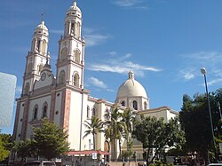
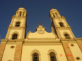
- Culiacán Cathedral, a 19th-century church, began construction in the 1830s.
- Plazuela Alvaro Obregón was the place for social gatherings in the 1800s.
- La Lomita or Templo de Nuestra Señora de Guadalupe is the tallest church in Culiacán, situated on a hill with a view of the entire city.
- The Regional History Museum in the "Parque Constitución", a large art museum downtown and several small art galleries, is owned by several local universities.
- The Botanical Garden and Centro de Ciencias de Sinaloa, a science museum, holds the fifth-largest meteorite on earth.
- A baseball stadium, the Estadio Angel Flores, is the home of Los Tomateros de Culiacán; a bigger football arena, called Estadio Banorte (formerly Estadio Carlos González), is the home of Los Dorados de Sinaloa, a Mexican football team.
- In addition, this city has a unique gastronomic diversity in its style.[23][24]
- Near the city there are many places to visit.[25]
Parks and green areas
editLas Riberas Park
edit Parque Las Riberas (in Spanish) is the area attached to the Tamazula and Humaya rivers. Different species of trees, such as willows, poplars, Guamúchiles, and eucalyptus, can be seen. The White Bimodal Bridge, which connects the park with the city center, facilitates access for pedestrians, and at night, it becomes a light show that contrasts with the Black Bridge in Culiacán.
Culiacán Botanical Garden
editLocated to the east of the city, this area is 10 ha and is home to different ecosystems and hundreds of plant and tree species, as well as the art installation Encounters by James Turrel. The Culiacán Botanical Garden has a variety of more than 2,000 plants.
Orabá Island
editOrabá Island, as its name indicates, is an island between the confluence of the Tamazula River and the Humaya River, where the Culiacán River is born. It is part of a series of parks and gardens that have been built on the banks of the three rivers.
Culiacán Zoo
editLocated next to the heart of the city, forming part of the Civic Center Constitución with an extension of 13.5 hectares, it houses 1,400 animals belonging to more than 450 species, including mammals, reptiles, and birds. It was built on 14 December 1950, as part of the Development Plan of the Sinaloa State Government, which contemplated the need to create a natural area that would contribute to promoting the education of flora and fauna existing in this region under the mandate of the State Governor. General Gabriel Leyva Velásquez, supported by Emilio Aguerreverre, Municipal President of Culiacán.
Tres Ríos water park
editThe Tres Ríos Water Park is a recreational space that was built at the confluence of the Humaya and Tamazula rivers, precisely where the Culiacán River is born.
This park is very close to Parque Las Riberas. It is the largest and most visited park in the northwest of the country.
Dancing fountains
editThe dancing or dancing fountains of Culiacán are a spectacle of hundreds of independent fountains programmed to "dance" to the sound of typical Sinaloan music. This show is presented every day in an area of the 3 Ríos Project where the flagpole is located, more specifically, at the mere confluence of the Humaya and Tamazula rivers.
Obregón Square
edit
Located on Álvaro Obregón Avenue.
Sports
editThe city is home to three professional league sports teams: baseball with the Tomateros de Culiacán from the Liga Mexicana del Pacífico, two championships in Caribbean series in 1996 and 2002; and football with Dorados de Sinaloa, who play at the Estadio Banorte (Estadio Carlos González) and basketball with the Caballeros de Culiacán from the CIBACOPA. Duck, dove, and goose hunting season goes from early November through March. Culiacán also holds a yearly international marathon.
Media
editNewspapers El Debate and El Noroeste are published in Culiacán.
Notable people
editSciences
editEntertainment
edit- Yolanda Andrade, TV host
- Luis Campos, drummer (Collinz Room, Noelia)
- Cesar Millan, dog trainer
- Paul Rodriguez, Hollywood actor and talk show host
- Chalino Sánchez, Mexican singer
- Sheyla Tadeo, actress and comedian
Sports
edit- Irene Aldana (born 1988), mixed martial artist
- Julio César Chávez, boxer with six world championships in three weight divisions[26]
- Julio César Chávez, Jr., former Middleweight champion[27]
- Omar Chávez, welterweight contender prospect[28]
- Óliver Pérez, Major League Baseball player
- Alberto Medina, footballer
- Jared Borgetti, footballer
- Jorge Iván Estrada, footballer
- Héctor Moreno, footballer
- Julio Urías, Major League Baseball player, World Series champion
- Joey Meneses, Major League Baseball[29]
- Ozziel Herrera, footballer
- Jesús Ricardo Angulo (born 1997), Mexican football winger
- Jesús Alberto Angulo (born 1998), Mexican football defender
Modeling
edit- Paulina Flores Arias, Miss Mexico 2000, model
- Rosa María Ojeda, Miss Mexico 2006
- Laura Elena Zuniga Huizar, Miss Mexico 2008, Miss Latinoamericana 2008, model
- Perla Judith Beltrán Acosta, Miss Mexico 2009, 2009 Miss World, model
Crime
edit- Benjamín Arellano Félix, Mexican drug lord, founder of Tijuana Cartel.
- Carlos Arellano Félix, Mexican drug lord.
- Francisco Rafael Arellano Félix, Mexican drug lord.
- Ovidio Guzmán López, Mexican drug lord
- Ramón Arellano Félix, Mexican drug lord, founder of Tijuana Cartel.
- Miguel Ángel Félix Gallardo, Mexican drug lord, founder of Guadalajara Cartel.
- Joaquín "El Chapo" Guzmán, Mexican drug lord.[8]
Gallery
edit-
-
 Culiacán's downtown
 -
 Culiacán street
 -
 Culiacán River by Sinaloa Blvd
 -
 "La Plazuela Rosales"
 -
 View north of Avenida Prol. Alvaro Obregon from Mirador La Lomita
See also
editReferences
edit- ^ "TelluBase—Mexico Fact Sheet (Tellusant Public Service Series)" (PDF). Tellusant. Archived (PDF) from the original on 13 January 2024. Retrieved 11 January 2024.
- ^ "Sinaloa – Culiacán". 3 September 2007. Archived from the original on 30 September 2007. Retrieved 3 July 2020.
- ^ García, María (2010). "Toponimia nahua de Sinaloa". Revista de Estudios Mesomericanos. 5 (2): 45–62.
- ^ "Etimología de los municipios de Sinaloa". Gobierno de Sinaloa. 15 March 2024. Retrieved 17 October 2025.
- ^ Astorga, Luis (1999). Drug Trafficking in Mexico: A First General Assessment (Report). UNESCO. Retrieved 1 March 2026.
- ^ Gootenberg, Paul (2008). Andean Cocaine: The Making of a Global Drug. University of North Carolina Press. ISBN 9780807859056. Retrieved 1 March 2026.
- ^ "Mexico's Sinaloa gang grows empire, defies crackdown". Reuters. 19 January 2011. Archived from the original on 12 March 2017. Retrieved 5 January 2023.
- ^ a b Villegas, Paulina (20 October 2019). "After Soldiers Surrender el Chapo's Son, a Shocked Mexican City Sighs with Relief". The New York Times. Archived from the original on 29 January 2022. Retrieved 29 January 2022.
- ^ Escudo de Culiacán. "Escudo". Archived from the original on 14 August 2020. Retrieved 10 September 2020.
- ^ "México a Culiacán Rosales". México a Culiacán Rosales. Archived from the original on 29 September 2023. Retrieved 3 July 2020.
- ^ "Sinaloa – Culiacán". 1 October 2013. Archived from the original on 13 October 2013. Retrieved 3 July 2020.
- ^ "Estado de Durango-Estacion: CULIACAN (DGE)". Normales Climatologicas 1991–2020 (in Spanish). Servicio Meteorológico Nacional. Retrieved 26 October 2025.
- ^ "Extreme Temperatures and Precipitation for Culiacan" (in Spanish). Servicio Meteorológico Nacional. Retrieved 26 October 2025.
- ^ "NORMALES CLIMATOLÓGICAS 1981–2000" (PDF) (in Spanish). Servicio Meteorológico Nacional. Archived from the original (PDF) on 30 January 2016. Retrieved 24 January 2016.
- ^ "Klimatafel von Culiacán, Sinaloa / Mexiko" (PDF). Baseline climate means (1961–1990) from stations all over the world (in German). Deutscher Wetterdienst. Archived (PDF) from the original on 24 February 2020. Retrieved 24 January 2016.
- ^ a b "INEGI – México en cifras". 20 April 2011. Archived from the original on 20 April 2011. Retrieved 10 September 2020.
- ^ "Ficha Municipal" (PDF). 22 November 2012. Archived from the original (PDF) on 22 November 2012. Retrieved 10 September 2020.
- ^ SEDESOL. http://cat.microrregiones.gob.mx/catloc/contenido.aspx?clave=250060001&tbl=tbl01.
{{cite web}}: Missing or empty|title=(help)[permanent dead link] - ^ "Comisión Nacional de Pueblos Indígenas" (PDF). Archived from the original (PDF) on 30 October 2020. Retrieved 10 September 2020.
- ^ De acuerdo a estimaciones del extinto INI a partir de la base de datos del XII Censo General de Población y Vivienda del INEGI 2000. Dimensión de la población hablante de lengua indígena de acuerdo con el número de hablantes, solo incluye personas de 5 años y más.
- ^ "¿Cuáles son las rutas de camiones urbanos en Culiacán en 2024?". Tus Buenas Noticias. 21 June 2024. Archived from the original on 16 July 2024. Retrieved 16 July 2024.
- ^ a b "Officials: Wiretaps, aides led to drug lord arrest". Boston.com.
- ^ "¿Las conoces? 4 panaderías en Culiacán para saborear los mejores panes artesanales". Tus Buenas Noticias. 21 June 2024. Archived from the original on 22 August 2024. Retrieved 27 June 2024.
- ^ "Tacos de Buche 'El Pariente' en Culiacán, los favoritos de culichis y famosos; conoce su inspiradora historia". Tus Buenas Noticias. 21 June 2024. Archived from the original on 16 July 2024. Retrieved 16 July 2024.
- ^ "Pueblos cerca de Culiacán, Sinaloa para visitar este fin de semana". Tus Buenas Noticias. 21 June 2024. Archived from the original on 27 June 2024. Retrieved 27 June 2024.
- ^ "Julio Cesar Chavez – Boxrec Boxing Encyclopaedia". Boxrec.com. 1 July 2012. Archived from the original on 16 October 2012. Retrieved 15 March 2013.
- ^ Elie Seckbach %BloggerTitle% (1 June 2010). "Julio Cesar Chavez Jr., Trainer Freddie Roach Workout". Boxing.fanhouse.com. Archived from the original on 23 July 2010. Retrieved 15 March 2013.
- ^ "Omar Chavez – Boxrec Boxing Encyclopaedia". Boxrec.com. Archived from the original on 25 February 2018. Retrieved 15 March 2013.
- ^ Stephen Mears (28 August 2022). "Joey Meneses is in rare air, but can it continue?". Archived from the original on 22 August 2024. Retrieved 17 September 2022.
External links
edit Culiacán travel guide from Wikivoyage
- (in Spanish) H. Ayuntamiento de Culiacán Archived 8 July 2010 at the Wayback Machine — Official website
- (in Spanish) Culiacán Travel Guide – Official website
